
Universitatis
Miskatoniciensis
Miskatoniciensis
Spatial Coverage Element HelpDefinitionSpatial coverage refers to the spatial characteristics of the intellectual content of the resource. Spatial coverage refers to a physical region (e.g., celestial sector) using place names. Spatial coverage is a geographic name given in a hierarchical form relating to the resource and includes a hierarchical form of place name which is both readable by humans and parsable by machines. This form can be applied to the degree of specificity that is known or relevant and used to generate browsable hierarchies even when values are specified to different levels. Explicit inclusion of the complete hierarchy is of potential benefit for automated consultation of a gazetteer to derive map coordinates or to support a map-based interface for searching by country or state. 1 The spatial coverage includes two distinct types of hierarchical geographic information:
As possible, differentiate between these two types during data entry. The subelements of the hierarchical spatial data are:
Form ElementThe online form element appears as below: 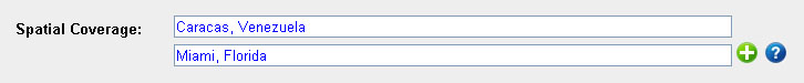 This form element allows the user to enter a spatial subject term, but does not allow the data to be entered hierarchically, nor is authority accepted. Data entered into this field defaults to being a hierarchical subject, mapped to the 662 MARC field, by adding the value SUBJ662 to the XML Node ID. Other form elements for entering spatial information include Hierarchical Spatial and Coordinates. Best PracticesEnter as much detailed information about the spatial information as possible, down to the actual area or address if possible. The area can generally be entered as commonly referenced ( such as "Caracas, Venezuela" ). To enter a deeper hierarchy for the spatial subject, you can use two dashes between the different levels of hierarchy ( such as "United States -- Florida -- Duval County -- Jacksonville -- Jacksonville Naval Air Station" ). Sources |
