
Universitatis
Miskatoniciensis
Miskatoniciensis
Hierarchical Spatial Element HelpDefinitionSpatial coverage refers to the spatial characteristics of the intellectual content of the resource. Spatial coverage refers to a physical region (e.g., celestial sector) using place names. Spatial coverage is a geographic name given in a hierarchical form relating to the resource and includes a hierarchical form of place name which is both readable by humans and parsable by machines. This form can be applied to the degree of specificity that is known or relevant and used to generate browsable hierarchies even when values are specified to different levels. Explicit inclusion of the complete hierarchy is of potential benefit for automated consultation of a gazetteer to derive map coordinates or to support a map-based interface for searching by country or state. 1 The spatial coverage includes two distinct types of hierarchical geographic information:
As possible, differentiate between these two types during data entry. The subelements of the hierarchical spatial data are:
Form ElementIn the online templates, this element appears as below: 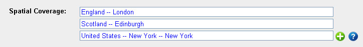 Another example with only one, fairly hierarchical example appears below:  Upon clicking or typing in the main box, the form below appears to give access to all the individual components of the hierarchical spatial subject: 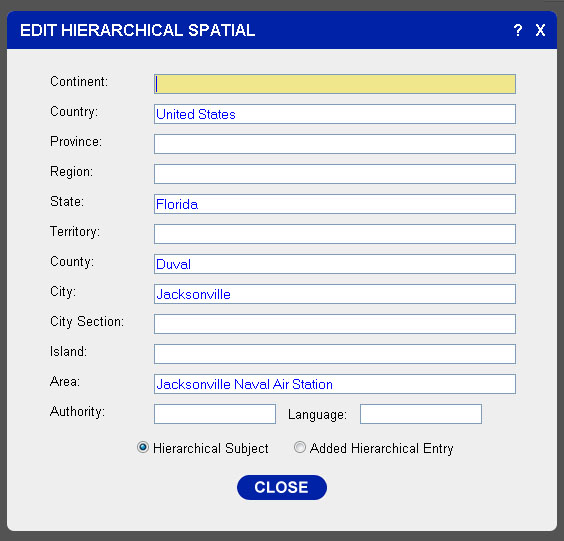 This form element is operated by clicking on the spatial term that the user would like to edit. When the user select a spatial term, the subject will appear in a pop up form. (Click on a link above to see the forms). This form element allows the user to enter the spatial coverage, setting the attribute for each of the subelements contained in the hierarchical geographic element. In addition, the user can select either Hierarchical Subject which represents the subject matter of the described item (analogous to the 662) or they can select Added Hierarchical Entry which can be additional information about the location of the publiser (analogous to the 752 field in MARC). This data is retained in the ID of the XML node for the spatial information, and is utilized when mapping (back) into MARC. Other form elements for entering spatial information include Simplified Spatial and Coordinates. Best PracticesEnter as much detailed information about the spatial information as possible, down to the actual area or address if possible. The continent subelement is often omitted if well-known or if the area is not always categorized as a single continent (such as portions of the Caribbean basin). Sources |
